


A tsunami tearing through the mountains is the only apt way to describe the recent flash floods in Nepal. With hundreds dead and thousands missing, it is one of the worst disasters to have befallen the country and one that raises urgent questions about what caused it, how the world has responded, and the deeper climate story behind why floods like this keep striking Nepal.
A Timeline of the Floods
Around 8:40 AM local time on 26th August 2026, as people opened up shop and did their morning prayers to start a new day of successful business, and as children rushed into their classrooms as they would on a regular Wednesday, a huge mass of glacier ice and bedrock roughly 1,200 metres up in the Himalayas along the Nepal-China border broke away and crashed onto the valley floor below (UN News, 2026). The collapse was massive to such an extent that seismic instruments measured it as a 5.2-magnitude earthquake, which the US Geological Survey and several experts later confirmed that the seismic signal was actually a consequence of the glacial collapse and debris flow, not the cause of it (Al-Jazeera, 2026).
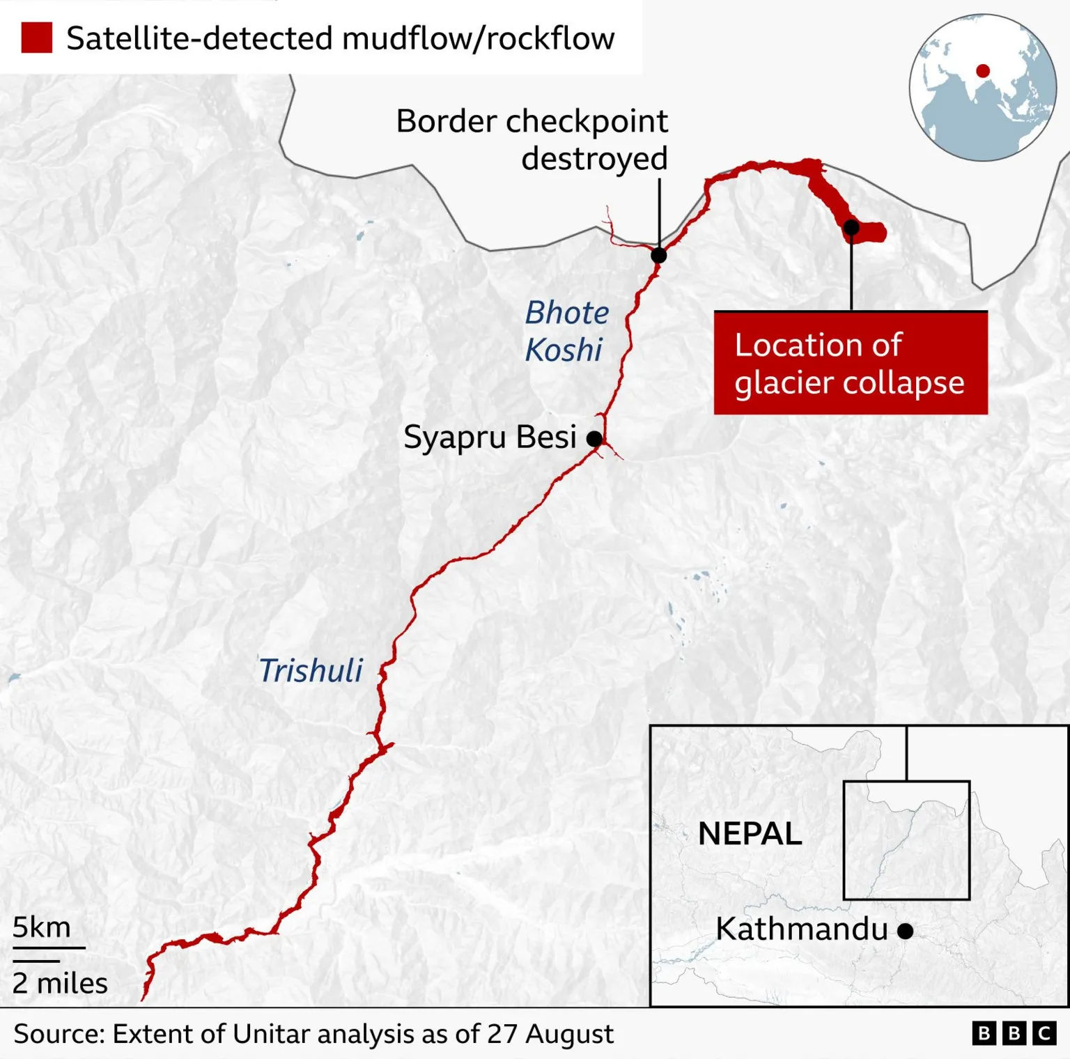
The landslide of ice and rock that triggered a flood carried debris down the Lhende River in Tibet, about 20km northeast of the Nepal-China border crossing at Rasuwagadhi (Al-Jazeera, 2026). The initial surge entered the Lhende Khola, which feeds into the Bhote Koshi and then the Trishuli River, carrying floodwaters south through Nepal, with water levels in the Trishuli reportedly rising by as much as 9 metres in just 30 minutes. In Rasuwa district, Timure and Syapru Besi were among the worst-affected settlements, with flooding reaching further downstream into Nuwakot and Dhading districts; across the border, mud and debris hit Gyirong Port in Tibet's Shigatse region (Al-Jazeera, 2026). The floods obliterated the Gyirong Port customs and immigration checkpoint at the Nepal-China border, and struck dozens of settlements along a 72 km stretch (NY Times, 2026).
Why it happened
It must be noted that this incident was not a ‘classic’ glacial lake outburst flood, with regards to a pre-existing lake bursting. Climate researcher Dipesh Chapagain from United Nations University claimed that rather than a glacial lake bursting, rock and ice collapsed from the mountainside and generated a torrent below, and stated, "this time, the intermediate step was skipped," adding that researchers were still investigating whether the debris temporarily dammed the river before the obstruction gave way (UN News, 2026). Prof Andrew Mackintosh, a glaciologist at Monash University in Melbourne, also expressed his concern about such an unprecedented glacier collapse, which was different than what they have observed previously. He said it was unclear whether the collapse was isolated to the glacier, or if it was the “whole mountainside collapsing that included part of the glacier” (The Guardian, 2026).
Copernicus situational reporting from 26th August states, “the flooding may have been caused by a glacial avalanche that temporarily blocked the Lhende Khola River, in a Himalayan region where accelerated glacier melt and increasingly extreme weather events are linked to climate change” (CEMS, 2026; AP News, 2026).
Thus, as of 30th August 2026, it is most accurate to say scientists agree on the broad mechanism of what happened (a glacial collapse triggered a debris flow that caused the flooding), but the deeper causal question of what exactly destabilized the glacier/bedrock at that moment, whether a temporary dam formed and failed, and how directly climate change is implicated, remains actively under investigation. As for the climate change aspect as well, experts say it is "too soon to tell conclusively" whether climate change directly caused this specific collapse, even though the broader warming trend in the Hindu Kush Himalaya (HKH) is well-documented context, with confirmed studies in how the HKH has witnessed 65% faster ice loss between 2011-2020 compared to the previous decade (ICIMOD, 2023).
Current Status (30th August 2026)
According to Nepal’s National Disaster Risk Reduction and Management Authority (NDRRMA) situation report dated 30th August 2026, 752 people have died with the largest casualties being in the Chitwan district, 239 people are injured, and over 2500 are missing.
Nepal’s Foreign Secretary Amrit Bahadur Rai stated that 19,000 security personnel and 16 helicopters have been mobilised in the search and rescue operations (Al-Jazeera, 2026). Having initially declined foreign help, Nepal has since opened the door to specialist international support: technical and tunnel-rescue teams from India (an 11-member National Disaster Response Force unit), China (5 emergency-management tunnel experts plus a 21-member rescue contingent with a search dog), and inspection teams from South Korea, while the US, Britain, Japan, Sri Lanka, and Bangladesh have also requested to send teams (The Kathmandu Post, 2026; The Pioneer, 2026). Broader relief has also come from the WHO (emergency medical supplies), the EU (satellite surveillance via Copernicus), and India (10 tonnes of humanitarian supplies, aircraft and helicopters) (BSS News, 2026).
On the financing end, the Asian Development Bank approved a $5 million emergency grant for rescue and relief operations (ADB, 2026), the UN released $2.5 million from the Central Emergency Response Fund to help get relief efforts moving (UNsdg, 2026), and UNICEF is separately appealing for $17.2 million to fund its emergency and early-recovery response for the more than 17,000 children affected by the disaster (UNICEF USA, 2026). Rescue efforts continue but remain hampered by damaged roads and destroyed bridges (The Climate Watch, 2026).
GLOFs, Climate Change, and Nepal
Nepal is unfortunately no stranger to GLOFs. Being situated right at the centre of one of the world’s most GLOF-prone regions, the HKH, Nepal has experienced multiple such events even before this year’s catastrophe.
Climate change is fundamentally reshaping the cryosphere of the HKH by accelerating glacier retreat and driving the rapid proliferation of glacial lakes across the region. The HKH is warming distinctly faster than the global average, a phenomenon known as elevation-dependent amplification, with the region's mean temperature having risen by roughly 0.10°C per decade over the past century and further increases of 1-2°C projected by 2050 (Shah & Ishtiaque, 2025; Chapagain et al., 2025). This warming has driven widespread glacier mass loss and fuelled the rapid formation and expansion of glacial lakes, with the Third Pole's inventory now standing at more than 26,000 lakes, roughly a third of which are highly prone to catastrophic failure (Zheng et al., 2021). Satellite analyses also show that the vast majority of assessed lakes have more than doubled in size in recent decades (Mir et al., 2025). This has translated into a clear, non-linear surge in glacial lake outburst floods (GLOFs): since 1950, the HKH has seen roughly a fivefold increase in GLOF frequency, with the most recent decades recording the highest counts on record (Chapagain et al., 2025). The underlying mechanism is well understood, that rising temperatures destabilize the moraine and ice dams that hold back glacial lakes, largely through ice avalanches, intense rainfall, and permafrost thaw, with these triggers concentrated during the summer monsoon when heat and precipitation both peak (Chapagain et al., 2025).
This escalating hazard is projected to intensify substantially as warming continues, while the region's capacity to adapt to it lags dangerously behind. Modelling suggests GLOF hazard and risk across the Third Pole could increase by close to threefold relative to today, with thousands of new glacial lakes potentially forming as glaciers retreat toward higher, steeper terrain that is more conducive to triggering avalanches (Zheng et al., 2021; Chapagain et al., 2025). While the eastern Himalaya currently holds the highest concentration of GLOF risk, new hotspots are expected to emerge further west in the Karakoram, Pamir, and western Himalaya as glaciers there also begin to lose mass. Transboundary GLOF threats are projected to roughly double, with hotspots concentrated along borders, as is already seen in the case of Nepal-China (Zheng et al.). More than five million people across Bhutan, Nepal, India, and Pakistan are already exposed to GLOF risk, and yet adaptation remains fragmented: only five of the eight HKH countries have GLOF-specific adaptation measures built into their national climate plans, funding falls well short of what is needed, and no transboundary early-warning framework exists despite over 200 glacial lakes shared across borders that could trigger cross-border disasters (Chapagain et al.).
Nepal, in particular, has recorded a warming trend that exceeds the global average over land, alongside measurable glacier shrinkage and a rapid annual expansion of glacial lake surface area between 1987 and 2017 at an even faster rate than the Himalaya-wide average (Khadka et al., 2023). This has translated into a long and growing history of disaster events, from the 1985 Dig Tsho GLOF that destroyed the Namche Small Hydel Project, to a 2016 GLOF originating in Tibet that caused extensive damage to the Bhotekoshi hydropower infrastructure (Shah & Ishtiaque, 2025), to today, as Nepal continues to reel under the impacts of the 2026 glacial collapse and flash floods.
Nepal has documented dozens of GLOF events to date, and its vulnerability to smaller, less-monitored lakes was starkly illustrated by the August 2024 cascading GLOF in the Thame Valley, where two previously overlooked small lakes breached in sequence after a period of anomalous heat and rainfall, causing an estimated USD 6.18 million in damage within just 22 minutes of the initial failure (Khadka et al., 2026). This event matters because it shows that climate-driven GLOF hazard isn't confined to the large, well-monitored lakes that dominate most risk assessments, but that small, fast-evolving lakes can also produce destructive floods that fall outside conventional screening thresholds, exposing a real gap in Nepal's (and the wider HKH's) risk management frameworks (Khadka et al., 2026). To its credit, Nepal has also been one of the more proactive countries in the region, implementing lake-lowering and early-warning systems at high-risk sites like Tsho Rolpa and Imja Tsho, alongside community-based adaptation measures such as forest conservation (Chapagain et al., 2025; Shah & Ishtiaque, 2025). But a substantial finance gap remains: Nepal's National Adaptation Plan estimates it needs roughly USD 1 billion by 2030 to build out comprehensive GLOF early-warning systems, yet the country has received only a small fraction of that in international climate finance to date, which highlights why Nepal remains both a focal point of GLOF hazard and a test case for climate adaptation finance in the HKH (Chapagain et al., 2025).
Cascading Impacts of GLOFs
When a glacier fails high in the Himalayas, the flood it unleashes doesn't just drown a valley, it can take down a nation's power grid, its food security, and its sense of safety along the way. The 2026 Bhotekoshi disaster is a stark reminder that cascading glacial hazards in Nepal rarely stay contained to a single valley.
Impacts to hydropower are the first cascading impact to usually come to light. The 1985 Dig Tsho GLOF alone destroyed a nearly completed hydropower plant and 14 bridges (Dubey et al., 2024), and the 2024 Thame cascade damaged the intake and desander of a local micro-hydropower scheme even as it displaced 135 people and destroyed a primary school (Khadka et al., 2026). Given that hydropower supplies roughly 93% of Nepal's electricity (Molden et al., 2022), repeated GLOF damage to run-of-river plants translates directly into national energy insecurity, not just local disruption, especially considering the fact that many such plants are built on historical hydrological assumptions that climate change is now rendering obsolete. There is also the dimension of national security, which is of importance to consider in light of current geopolitical tensions. Survey-based research across Nepal's high-risk Himalayan districts found that GLOFs are perceived not merely as natural hazards but as threats that strain governance capacity, trigger displacement-driven migration and resource competition, and create exploitable vulnerabilities in critical infrastructure and border regions (Bhandari & Adero, 2025). Because many of Nepal's most dangerous glacial lakes sit in transboundary catchments shared with China, a collapse like the most recent one can simultaneously damage infrastructure, bridges, and settlements across both countries, complicating rescue coordination and raising the stakes for cross-border early-warning cooperation (Dubey et al., 2024).
Here is where loss and damage framing can also come into play, since these are not abstract climate statistics but irreversible losses of homes, farmland, schools, and, in the worst cases, entire settlements erased in minutes. Nepal's own attribution research shows that anthropogenic warming has already made extreme heat and rainfall events in its physiographic regions up to three times more likely, feeding the glacier retreat and lake formation that precede these disasters (Dhakal et al., 2026), and yet the non-economic losses of trauma, cultural erasure, and the severing of generational ties to land remain systematically under-documented, largely because Nepal's disaster institutions still lack standardized valuation protocols for anything beyond destroyed infrastructure (Dhakal et al., 2026).
Taken together, these cascading impacts argue for treating GLOF risk as a systemic governance problem rather than a series of isolated events. Nepal's own researchers point to fragmented institutional mandates, weak inter-agency coordination, and underinvestment in ex ante physics-based attribution studies as the central obstacles to both effective domestic response and Nepal's ability to draw on international loss and damage finance, including the Fund for Responding to Loss and Damage (Dhakal et al., 2026). Until small, previously overlooked glacial lakes are systematically monitored alongside the well-known large ones, and until exposure and vulnerability, not just the glaciers themselves, become the focus of risk reduction, disasters like Thame in 2024 and the far larger Bhotekoshi collapse of 2026 will keep repeating, each time testing anew whether Nepal's hydropower grid, its communities, and its governance systems can absorb the shock.
The work that remains
Nepal has now lived through this same story too many times to call it a series of isolated tragedies: Dig Tsho in 1985, Bhotekoshi in 2016, Thame in 2024, Rasuwagadhi in 2025, and now the Bhotekoshi disaster of 2026, the deadliest of them all. Each time, the questions asked are strikingly similar: How much warning did we have? Could this have been predicted? Why did the response take so long to reach the people who needed it most? And each time, the answers point back to the same unresolved gap between what science already knows about a warming Himalaya and what Nepal's institutions, and the international community, have actually funded and built to meet it.
What makes 2026 different is the scale of what a single event revealed all at once. Hundreds are dead, a hydropower corridor that powers a nation's grid was reduced to rubble in half an hour, and a border crossing between two countries wiped off the map. This was a stress test for everything downstream of a melting glacier: infrastructure, diplomacy, disaster governance, and the quiet, unglamorous work of climate finance that rarely makes headlines until it's too late. The uncomfortable truth this disaster leaves behind is that Nepal cannot out-build its way to safety on infrastructure alone, nor can it out-monitor the mountains with the patchwork of early-warning systems currently in place at a handful of well-known lakes. As Thame proved in 2024, and as Bhotekoshi has now proven at a devastating scale, the next disaster is just as likely to come from a small, unmapped lake or an unstable slope no one was watching, as from the giants scientists already track. The real work ahead isn't just rebuilding what the floodwaters took, but confronting the fact that Nepal's mountains are changing faster than its systems for living safely beneath them. Until that changes, the mountains that shape so much of Nepal's identity and livelihood will continue to hold both beauty and risk in the same space, and closing that gap is the work that remains.