


How Small Countries Influence Large Rivers
Remember the last time you lied and didn’t get caught. Well, that’s what maps have been doing since the days of “once upon a time.” Maps are excellent liars. They convince us that influence increases with area, that power follows borders, and that small countries should politely follow larger nations. Here’s the catch: hydrology disagrees. In water science, leverage is not about size; it is about where you sit in the ecosystem. Nepal occupies one of the most strategically inconvenient positions in Asia’s water network, where gravity, climate, and topography all unite to amplify hazards. Archimedes once claimed that with a long enough lever and the right fulcrum, he could move the Earth. Hydrology tells the same. Nepal is the lever by position: a steep, elevated fulcrum where small shifts in climate patterns translate into large downstream effects.
Nepal does not just “supply” water to Asia’s rivers. It conditions and influences them. The rivers leaving Nepal are already shaped, accelerated, sediment-loaded, and seasonally synchronized long before they reach the plains. This shaping occurs because extreme elevation gradients, intense monsoon rainfall, and seasonal snow and glacier melt interact over very short distances, rapidly converting climate signals into runoff, sediment, and flood waves. By the time these rivers cross Nepal’s southern border, their timing, energy, and sediment characteristics are largely determined. By the time the Koshi, Gandaki, and Karnali enter India, they are not blank slates. They are fully conditioned systems, carrying the imprints formed by Nepal’s mountains, climate, and hazards.
This is why Nepal matters disproportionately. It is not a storage tank at the edge of Asia’s water tower; it is a control valve embedded deep within the water system of Asia. Control valves, as engineers know, tend to decide outcomes. In river systems, those outcomes determine when floods arrive, how destructive they become, and how reliable water remains during dry seasons far downstream.
Every River Has a Childhood: Most of Asia’s Begin in Nepal
Rivers are often discussed as if they are born mature: wide channels, stable banks, predictable flows. In reality, rivers spend their formative years learning how to behave. This “childhood” phase, where slopes are steep, channels are unstable, and water is energetic, dictates much of what the river will become downstream.
For much of South Asia, that childhood happens in Nepal. Remember learning that slope is the ratio of vertical drop to horizontal distance. For these rivers, that “slope” is significantly high, and this is where the game begins. The average descent in Nepal’s high-altitude catchments can exceed 60 meters per kilometer, producing flows with remarkable energy and erosive power that shape channels hundreds of kilometers downstream (Wester et al., 2019). Here, rivers descend from some of the highest elevations on Earth to the lowland plains over remarkably short horizontal distances. In doing so, they carve valleys, mobilize sediment, and establish flow regimes that persist far downstream. By the time these rivers reach flatter terrain, their personalities are already set.
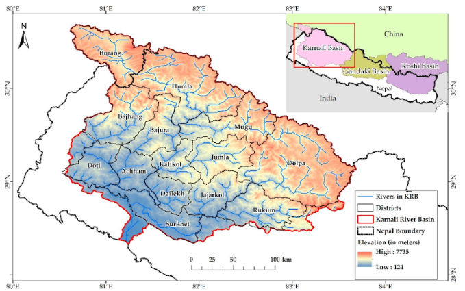
Figure 1: Map of river basins in the Nepal Himalayan region, showing transboundary flow into the Ganges system.
Source: (Shrestha et al., 2019)
This matters because early-stage river processes dominate long-term behavior. Flood magnitude, sediment load, and channel migration tendencies are not accidents of the plains; they are legacies of the mountains. Nepal’s role is therefore not optional or symbolic; it is foundational. If rivers were biographies, Nepal would write the thrilling opening chapters, with floods, sediment, and meanders all receiving their first instructions here. Everything downstream is just a sequel, and the mountains hold the copyright.
How Extreme Topography Turns Water into Momentum
Nepal’s most underrated hydrological feature is not its glaciers or snowfall, but its topography. Within less than 200 kilometers, elevation rises from about 60 meters above sea level to over 8,000 meters. First, it accelerates runoff: rainfall and meltwater do not linger.
They move rapidly, gaining higher flood peaks, especially during intense monsoon events. Second, it mobilizes sediment at scale. Steep slopes combined with fragile geology make Nepal one of the world’s most sediment-productive regions. Landslides, bank erosion, and debris flows inject enormous sediment loads into rivers, altering channel geometry far downstream (ICIMOD, 2019). Third, it amplifies extremes. The same rainfall event that produces moderate flooding in flatter terrain can generate destructive floods in steepbasins. Gravity, unburdened by diplomacy or development plans, does most of the work.
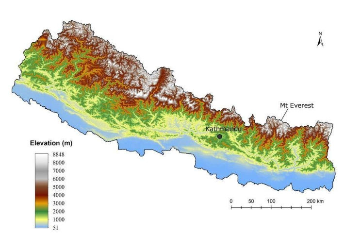
Figure 2: Elevation map of Nepal. It shows over a short North-South distance, the elevation drops from over 8000m to below 100m highlighting the compressed vertical relief that drives rapid runoff and sediment mobilization.
Source: (Reddy et al., 2018)
In hydrological terms, Nepal converts water into momentum. Once momentum is acquired, it does not politely disappear at borders.
Where Snow, Ice, and Monsoon Are Forced to Work Together
Nepal sits at one of the most complex climate intersections on the planet: where the South Asian monsoon collides with the high-altitude cryosphere. Snowmelt, glacier melt, and rainfall overlap and interfere here. Historically, this coupling created a seasonal buffering effect. Snow and glacier melt sustained dry-season flows, while monsoon rains replenished storage and recharged systems. The timing generally worked. Warming is now disturbing that setting. Rising temperatures shift melt earlier in the year, weakening late-season buffering and increasing reliance on monsoon rainfall for peak flows (IPCC, 2021). At the same time, monsoon precipitation is becoming more variable, with a tendency toward high-intensity short-duration events. Nepal, because of its elevation range, experiences these changes first and most sharply. It acts as a climate signal magnifier, translating gradual atmospheric shifts into pronounced hydrological responses. Small changes in temperature or precipitation patterns upstream produce outsized effects downstream. This is not theoretical. Observed trends across the HKH already show altered flow seasonality and increasing variability linked to the cryosphere–monsoon interactions. Nepal is not just feeling the effects of climate change; it is broadcasting them.
Rivers That Export Climate Signals
The Koshi, Gandaki, and Karnali are often described as Nepal’s major rivers. Hydrologically, they are something more specific: export systems. They carry not only water but information about climate, land stability, and upstream into the Ganges Basin.
In practical terms, this information is embedded in flow timing, sediment concentration, and discharge variability. Studies show that a large fraction of peak monsoon discharge and sediment load in the Ganges Basin originates in the Himalayan headwaters, with Nepal contributing disproportionately due to steep slopes, intense rainfall, and active tectonics (Wester et al., 2019). These rivers, therefore, transmit upstream climate signals downstream with remarkably little dampening. During the pre-monsoon season, snowmelt and glacier melt raise baseflows, priming river channels before monsoon rainfall arrives. When monsoon storms follow, already-elevated flows amplify flood peaks and sediment transport, particularly in rivers like the Koshi and Gandaki (Bolch et al., 2019; Immerzeel et al., 2020). This coupling makes Nepal a hydrological amplifier rather than a passive conduit. What happens here directly shapes flood risks, sedimentation patterns, and water availability in northern India and Bangladesh.
Crucially, downstream impacts are often nonlinear. A relatively small increase in upstream sediment supply can sharply reduce downstream reservoir storage and hydropower efficiency, as observed in multiple Ganges Basin reservoirs (Kondolf et al., 2014). Similarly, changes in flood timing, such as earlier monsoon peaks driven by warmer pre-monsoon conditions, can disrupt agriculture and infrastructure designed around historical flow calendars rather than future ones (IPCC, 2021).
When Local Hazards Refuse to Stay Local
Nepal is one of the world’s most hazard-prone regions, not because it is unlucky, but because its geography is uncompromising. Floods, landslides, and glacial lake outburst floods (GLOFs) are not anomalies here; they are system behaviors. These hazards arise from the coupling of steep relief, fragile geology, intense monsoon rainfall, and warming cryosphere conditions that repeatedly push mountain slopes and river systems beyond their stability thresholds. What makes these hazards regionally significant is their propagation potential. A landslide in a tributary can generate sediment pulses that raise riverbeds hundreds of kilometers downstream. Large landslide-driven sediment pulses from the Koshi and Karnali basins have repeatedly altered channel capacity downstream, increasing flood risk and reducing the effectiveness of embankments and reservoirs in northern India. A GLOF can send destructive surges across borders within hours. Such events compress response time to near zero, turning upstream ice loss into a downstream disaster before warning systems can realistically intervene. Recent assessments identify Nepal as a critical hotspot for compound hazards, where climate change intensifies existing risks rather than introducing entirely new ones (Wester et al., 2019). The country is simultaneously a victim of these processes and an unwitting source of downstream risk.
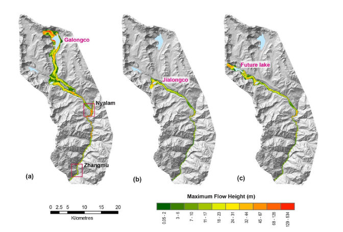
Figure 3: Glacial lake outburst flood (GLOF) hazard assessment map and downstream areas, showing propagation potential across borders. Source:(Allen et al., 2022)
This dual role complicates adaptation. Nepal bears the immediate damage, while downstream regions bear delayed but widespread consequences. Responsibility, however, is rarely shared proportionally. In the HKH, hazards may originate locally, yet the associated risks are exported regionally, often without shared governance, shared data, or shared accountability.
The Unassigned Responsibility Everyone Depends On
Nepal contributes a negligible fraction of global greenhouse gas emissions. Yet it occupies one of the most consequential positions in Asia’s hydrological system. This is the responsibility paradox: low contribution, high leverage. Regional water security, flood safety, dry-season flows, and sediment management depend heavily on processes unfolding in Nepal’s mountains. Yet, scientific investment, monitoring infrastructure, and transboundary cooperation remain uneven. Tectonics made the appointment millions of years ago. Ignoring it is no longer an option. If Asia’s water future is to be managed rather than endured, Nepal’s hydrological centrality must be treated as a shared concern, not a local inconvenience. The rivers will carry the consequences regardless. The only question is whether the region chooses to understand them in advance.
Nepal is not just upstream of Asia’s rivers. It is upstream of Asia’s water decisions. Understanding its role is not an academic exercise; it is a prerequisite for regional stability in a warming world.
References
Allen, S. K., Sattar, A., King, O., Zhang, G., Bhattacharya, A., Yao, T., & Bolch, T. (2022). Glacial lake outburst flood hazard under current and future conditions: Worst-case scenarios in a transboundary himalayan basin. Natural Hazards and Earth System Sciences, 22 (11), 3765–3785. https://doi.org/10.5194/nhess-22- 3765-2022
Bolch, T., Shea, J. M., Liu, S., Azam, F. M., Gao, Y., Gruber, S., Immerzeel, W. W., Kulkarni, A., Li, H., Tahir, A. A., Zhang, G., & Zhang, Y. (2019). Status and change of the cryosphere in the extended hindu kush himalaya region. In P. Wester,
A. Mishra, A. Mukherji, & A. B. Shrestha (Eds.), The hindu kush himalaya assessment: Mountains, climate change, sustainability and people (pp. 209–255). Springer International Publishing. https://doi.org/10.1007/978-3-319-92288-1 7
ICIMOD. (2019). Major river basins in the hindu kush himalaya [Available at ICIMOD Regional Database System].
Immerzeel, W. W., Lutz, A. F., Andrade, M., et al. (2020). Importance and vulnerability of the world’s water towers. Nature, 577, 364–369. https://doi.org/10.1038/s41586- 019-1822-y
IPCC. (2021). Climate change 2021: The physical science basis. contribution of working group i to the sixth assessment report of the intergovernmental panel on climate change (V. Masson-Delmotte, P. Zhai, A. Pirani, S. L. Connors, C. P´ean, S. Berger,
N. Caud, Y. Chen, L. Goldfarb, M. I. Gomis, M. Huang, K. Leitzell, E. Lonnoy,
J. B. R. Matthews, T. K. Maycock, T. Waterfield, O. Yelek¸ci, R. Yu, & B. Zhou, Eds.). Cambridge University Press. https://doi.org/10.1017/9781009157896
Kondolf, G. M., Gao, Y., Annandale, G. W., Morris, G. L., & Jiang, E. J. (2014). Sustainable sediment management in reservoirs and regulated rivers: Experiences from five continents. Earth’s Future, 2 (5), 256–280. https://doi.org/10.1002/ 2013EF000184
Reddy, C. S., Pasha, S. V., Satish, K. V., Saranya, K. R. L., Jha, C. S., & Murthy,
Y. V. N. K. (2018). Quantifying nationwide land cover and historical changes in forests of nepal (1930–2014): Implications on forest fragmentation. Biodiversity and Conservation, 27 (1), 91–107. https://doi.org/10.1007/s10531-017-1423-8
Shrestha, B., Ye, Q., & Khadka, N. (2019). Assessment of ecosystem services value based on land use and land cover changes in the transboundary karnali river basin, central himalayas. Sustainability, 11 (11). https://doi.org/10.3390/su11113183
Wester, P., Mishra, A., Mukherji, A., & Shrestha, A. B. (Eds.). (2019). The hindu kush himalaya assessment: Mountains, climate change, sustainability and people. Springer International Publishing. https://doi.org/10.1007/978-3-319-92288-1